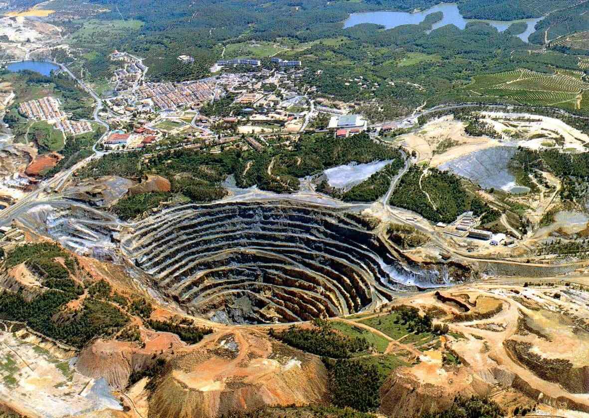
Vistas de página en total

miércoles, 28 de diciembre de 2011

"FERIA DE ABRIL" OF SEVILLE (24 to 29 of April 2012) Enjoy this incredible festival of Seville with www.spainsouthwest.com (legal assistance and touristic services)
Many people are shocked to find out that Sevilla's extravagant Feria de Abril (April Fair), a week-long festival bursting with a vibrance that only those "carpe diem" sevillanos can pull off, began long ago as a simple agricultural fair. Nowadays, the livestock stalls are long gone, making room  for the colors, music and festivities of this ultimate celebration of simply enjoying life. The week of round-the-clock fiestas begins with the midnight alumbrado, for which Sevillanos and visitors alike turn out in droves to get their first look at the lit up feria grounds. The elated crowd bursts into cheers as more than 22,000 lightbulbs flicker into action, joyfully illuminating the grounds and the towering main gateway, which architects design and construct anew every single year. 


From this moment until the end of the week, the fair grounds – which come to life exclusively during the Feria – brim with the energy created by lively music, dancing and the cheerful colors of those infamous polka-dotted flamenco dresses. Over 1,000 striped casetas line the Feria streets,varying in size from huge tents donning the names of associations or political parties to more intimate versions belonging to families and groups of friends. 


The real essence of the feria lies in these smaller casetas, where everyone knows everyone and which the owners take great pride in decorating like a second home. Large and small casetas alike have music playing, a small kitchen, tables and chairs, a bar serving beer, sherry, and tapas, and an indispensable open space for dancing the joyful sevillanas, the four-part local flamenco spin-off that Sevillanos begin learning from the moment they begin to walk. 

Sevillanas The four-part songs – and accompanying dances - known as sevillanas originated in medieval Sevilla and consist of improvised verses accompanied by flamenco guitar and clacking castanets. To see these joyful sevillanas as they're meant to be seen, follow the locals to Sevilla's Feria de Abril and maybe they'll even teach you a few steps.


martes, 27 de diciembre de 2011


THE HORSE RACES OF SANLUCAR DE BARRAMEDA (enjoy this event with www.spainsouthwest.com)

The oldest officially-regulated horse race which still exists in Spain today was held on the beach in 1845 in one of the three towns of Cádiz province which, together with Jerez de la Frontera and El Puerto de Santa María, make up the world-famous sherry triangle: Sanlúcar de Barrameda.
According to tradition, the Carreras de Caballos owe their origins to the informal races which used to take place between the owners of the working horses which were used to transport fish from the former port of Bajo de Guía to the local markets and other nearby towns.

The first race was organised by an association which was set up specifically to promote the Andalucía breed of horse, the Sociedad de Carreras de Caballos de Sanlúcar de Barrameda. It has been held almost without interruption ever since, and now straddles the festivities held in honour of the town’s patron saint, Nuestra Señora de la Caridad Coronada.
This annual race on the flat southern sands of this part of Andalucía is today renowned all over the world, and has been classed as International Tourism Interest since 1997. The King of Spain, Juan Carlos I, is Honorary President of the Racing Club.

The races take place every August, and are spread over two separate three-day events.
At low-tide at the mouth of the Guadlquivir River, just as the sun is setting, and with the marshes of the Doñana National Park as the backdrop across the other side of the river.

The racehorses run for distances ranging between 1.2 and 2 kilometres, while a crowd of thousands watches jockeys from Spain and elsewhere in Europe resplendent in their racing colours as the horses’ hooves pound across the wet sands. There is official betting, with an unofficial system run by children on the side, and total prize money running into the millions.

The largest purse is awarded during the last weekend of the races, for the first horse to cross the line in the two kilometre stretch in the Gran Premio Ciudad de Sanlúcar.

Traditionally, the races take place the second and fourth weeks of August from Thursday to Sunday.
This is a splendid event that attracts people from all over the country and, of course, from beyond Spanish borders as well. It officially dates back to the year 1845 when the the Sociedad de Carreras de Caballos de Sanlucar de Barrameda was formed.
Some time after its beginnings, the Sociedad de Carreras de Caballos de Sanlucar de Barrameda handed this ever more prestigious event over to the town hall for management and it was then included in the town’s summer programme of municipally sponsored events. It became known as one of the most important “fiestas” in the region.

Then, in 1981, the Sociedad de Carreras de Caballos de Sanlucar reformed and took back the reigns of the annual races. According to reports, the event is now better organised than ever. What’s more, the Sanlucar Horse Races are now part of a national series of equine events that include Madrid, San Sebastian and Seville.

Jockey and his thoroughbred, Sanlúcar.

Now the Sanlucar de Barrameda races attract horses and riders from all over Europe. This is not surprising as the stakes are high with total prize monies running between 2 and 3 million euros. Per race winnings run from a few hundred to up to 10,000 euros as of 2008.
Should you with to experience the Sanlucar races live, be sure to book your hotel well in advance and get to the beach as early as possible to stake out a good place for an exciting event held at a unique venue that begins at 6:00 in the evening.
Along the shore of Sanlúcar de Barrameda, these are the oldest official horse races in Spain

viernes, 23 de diciembre de 2011


EMERITA AUGUSTA (MÉRIDA A HISTORICAL ROMAN CITY) 

Discover this historic city where the Romans left their mark with the trips of www.spainsouthwest.com 


The Archaeological Ensemble of Mérida is one of the largest and most extensive archaeological sites in Spain. Mainly of Emerita Augusta, ancient capital of Lusitania (current city of Mérida). It was declared a World Heritage Site by UNESCO in 1993.

Roman Theatre

The theatre was built from 15 to 16 BC and dedicated by the consul Marcus Vipsanius Agrippa. It was renovated in the late 1st or early 2nd century AD, possibly by the emperor Trajan, and again between 330 and 340 during Constantine's reign, when a walkway and new decorative elements were added. With the advent of Christianity as Rome's sole state religion, theatrical performances were officially declared immoral: the theatre was abandoned and most of its fabric was covered with earth, leaving only its upper tiers of seats (summa cavea). In Spanish tradition, these were known as "The Seven Chairs" in which several Moorish kings held court to decide the fate of the city.


Roman Amphitheatre

The amphitheatre was dedicated in 8 BC, for use in gladiatorial contests and staged beast-hunts. It has an elliptical arena, surrounded by tiered seating for 15,000 spectators. The seating is divided according to the requirements of Augustan ideology, with the lowest seats reserved for the highest status spectators. Only this lowest tier survives. When the games fell into disuse, the amphitheatre's upper tiers were quarried for stone, for use in new buildings nearby.


Roman Circus

The circus of Emerita Augusta was built some time around 20 BC, and was in use for many years before its dedication some thirty years later, probably during the reign of Augustus' successor, Tiberius. It was sited outside the city walls, alongside the road that connected Emeritus in Corduba (Córdoba) with Toletum (Toledo). The arena plan was of elongated U-shape, with one end semicircular and the other flattened. A lengthwise spina formed a central divide within, to provide a continuous trackway for two-horse and four-horse chariot racing. The track was surrounded by ground level cellae, with tiered stands above. At some 400m long and 100m wide, the Circus was the city's largest building, and could seat about 30,000 spectators – the city's entire population, more or less. Like most circuses throughout the Roman Empire, Merida's circus resembled a much scaled-down version of Rome's Circus Maximus.


Roman bridge over the Guadiana


The situation of the bridge is carefully selected at a ford of the river
 Guadiana offered as a support a central island that divides it into two channels. The original structure did not provide the continuity of the present, as it was composed by two sections of arches joined in the island, where a large Starling. This was replaced by several arcs in the seventeenth century, after a flood dated in 1603 damaged part of the structure. In Roman times the length was extended several times, adding at least five consecutive sections of arches so that the road is not cut during the periodic flooding of the Guadiana. That has made this work reaches the 792 m long, one of the largest remaining at that time.Can be considered, somehow, as the source of the city and in any event, which marks its route to be extended from one of the main arteries of the colony, the Decumanus Maximus.


Aqueduct of Los Milagros


The arcade is now fairly well preserved, especially the section that spans the valley of the river Albarregas.
Part of the transfer that brought water to Merida from the Proserpina Dam located 5 km from the city. Dates from the early 1st B.C. century.
It is known by this name, because it seems a miracle that it was still standing.


Aqueduct of Rabo de Buey-San Lázaro

Brought water from streams and underground springs located north of the city; the subterranean part of the aqueduct is very well preserved but of the structure built to cross the Albarregas valley, there only survives three pillars and their arches next to the monument of the Roman circus and to another aqueduct of the 16th century, in which material was reused from the Roman aqueduct.


Temple of Diana

Rectangular, and surrounded by columns, it faces the front of the city's Forum. This front was formed by a set of six columns ending in a gable. It is mainly built of granite.This temple is a municipal building belonging to the city forum. It is one of the few buildings of religious character preserved in a satisfactory state. Despite its name, wrongly assigned in its discovery, the building was dedicated to the Imperial cult. It was built in the late 1st century B.C. or early in the Augustan era.


Arch of Trajan

Entrance arch, possibly the provincial forum. Was located in the Cardo Maximus, one of the main streets of the city and reported it to the municipal forum. In his time was covered with marble.
Made of granite and marble wrapped in origin, it measures 13.97 meters high, 5.70 m wide and 8.67 m for arc flash. It is believed to have a triumphal character, although it could also serve as a prelude to the Provincial Forum. Immersed in the maze and masked by modern construction nearby houses, this arch stands majestic and admired by travelers and historians of all time. Its name is arbitrary, as the commemorative inscription was lost centuries ago.


House of the Mithraeum

It was found fortuitously in the early 1960s, and is located on the southern slope of Mount San Albín. Its proximity to the location of Merida's Mithraeum led to its current name. The whole house was built in concrete blocks reinforced corners. Highlights the peristyle house with interior garden and a room of the famous western sector Cosmogonic Mosaic, allegorical of the elements of nature (rivers, winds, etc.) chaired by the figure of Aion. The complex has been roofed and fitted out to visit recently.


Los Columbarios

With this name are called two buildings funeral, held in the open, outside the walls of the Roman city. Both are the best example of funerary constructions Emeritus. The materials used for manufacturing are the masonry and granite masonry. In the two sections are preserved identification epigraphies of the owner families (the Vaconios and Julios) as it has been known the origin and condition of them.


Alcazaba

Next to the Roman bridge of the Guadiana River. Built by Abderraman II in 835 d. C. as a stronghold to control the city, which since 805 had rebelled continuously against the rule of the Emirate. First Arab citadel of the Iberian Peninsula.
It is a complex construct, consisting of a large area of 130 square meters on a side capable of accommodating a large number of troops. Inside are a wonderful aljibe, where building is unique, consisting of an inexhaustible water tank (filtered from the Guadiana) that was accessed with a double row from the ground floor of a tower. At one end was built a convent for the Order of Santiago and is now the seat of the presidency of the Junta de Extremadura. Next to the Roman bridge is attached another smaller room, called Alcazarejo, which controlled the river crossing the city.

jueves, 22 de diciembre de 2011

EL ROCIO´S PILGRIMAGE (since 23 to 28 May 2012, Almonte,Huelva) visit it with www.spainsouthwest.com


The El Rocío Pilgrimage, one of the biggest in the world and one with the largest crowds. the Pilgrimage properly speaking starts on the Saturday, the pilgrims begin this annual event by travelling the pilgrims' trail (which forms part of the whole ritual). This takes a few days, during which time they travel in each others' company, on foot, on horseback or in horse-drawn carriages, sleeping under the stars, until they reach the village.

   
Many pilgrims say that "El Rocío is travelling the trail" (meaning that travelling the pilgrims' route is the most important part of the pilgrimage) - because during those few days they travel in one another's company, pray, sing, live together as a fraternity, and make their way towards the One for whom they feel such devotion. The duration of the pilgrimage depends on how far the pilgrims' home town or village is from the Almontese village of El Rocío, but it can vary from 1 to 7 days. 

Pilgrims usually wear very characteristic, traditional Andalusian costumes: the men a short jacket and tight trousers, suitable for horseriding, and the women a Flamenco costume; or a "bata rociera", which is a simpler version of the former that is suitable for walking or horseriding; or a "falda rociera" (a light, flouncy skirt typically worn on this pilgrimage). And, or course, not forgetting the tall boots, made in one piece.

 After the journey to get there, the pilgrimage begins at 12 noon on the Saturday with the Presentation of the Fraternities, a ceremony which goes on until well into the night, and during which the different fraternities which make the pilgrimage to El Rocío - in reverse order of the number of years since their foundation - pass in front of the Shrine, paying their respects by presenting the Immaculate Conception emblem borne by their standard bearer. When the Emblem is borne into the Shrine (the timing of which is not known in advance), the Almontese jump the railing to take their Patron Saint out in procession. Protectively surrounded by thousands of pilgrims, the Virgin of El Rocío is carried through the village streets until after midday on the Monday, when she returns to her Shrine, signalling the end of the Pilgrimage. 

From this time onwards, the fraternities start on the journey back to their localities and on the countdown to another visit to see the White Dove. 

But besides participating in the acts of devotion, in El Rocío the pilgrims sing, dance, eat, drink, have fun... and make a good display of the open, joyful nature of the people of this land.

martes, 20 de diciembre de 2011


CORTA ATALAYA, RIO TINTO´S MINE, HUELVA
(Visit it with www.spainsouthwest.com)
 
Corta Atalaya is the largest open-pit mine in Europe and was at one time the largest in the world. 
Itis located within the city limits of Minas de Riotinto in the province of Huelvaautonomous community of AndalusiaSpain. It is roughly elliptical in shape, 1,200 metres (3,900 ft) long, 900 metres (3,000 ft) wide, and 350 metres (1,150 ft) deep. It was one of the most ambitious projects of the Rio Tinto Group. At its peak it employed 2,000 workers; it was actively mined until 1992. Since at least 1994 it has been flooded up to the 16th ring


This open-pit mine in the western part of the Masa San Dionisio was begun in 1907 after major subsidence in some of the higher-altitude parts of the area two year earlier, caused by the combustion of pyrites in the earlier subterranean mines. The mines were nationalized in 1954 but later sold back to a private company. As of October 2009, the current owner, EMED Tartessus, says they will have the mine operating again before the end of 2010.

Geology
Corta Atalaya is a mine in western part of the Iberian Pyrite Belt. It is part of a zone of volcanogenic massive sulfide ore deposits of Silurian to Carboniferous age which has produced significant copper, zinc, lead, gold and silver.
La Atalaya


The village of La Atalaya was constructed for the subterranean mining of the San Dionisio seam, which in 1907 became the Corta Atalaya open-pit mine.
In 1873, Rio Tinto Company, later Rio Tinto Group, acquired the mines of Riotinto. Encountering the problem of transporting miners from their homes to their workplaces, and taking only economic concerns into consideration, they planned construction of houses where the miners had already built huts to stay overnight near the mines. Thus, the village of La Atalaya was founded in 1883. The company simply substituted more durable buildings for the huts, constructing neighborhoods in the locations the miners had already chosen. Construction began on 100 houses, each of 45 square metres (480 sq ft), providing only the most minimal necessities of lodging.
The company then went on to build a public plaza, chapel, grocery store, casino, school, and a Guardia Civil barracks. For almost a century, this was home to many of the miners, first those working in the subterranean mine and then in the Corta Atalaya open pit. The population peaked around 1910.
In 1970, La Atalaya had 257 buildings and a population of 823. That year, approval was received to enlarge the pit; in 1971, La Atalaya was destroyed because it was in the path of the mining.
La Atalaya was not the only townsite sacrificed to the mine. Earlier, the original location of Minas de Riotinto lay in the path of the mine; the town was moved to its present site.

.- touristic train
After closure

As of 2007, EMED Mining owns 51% of the mine. EMED Mining has established EMED Tartessus, which is currently tasked with cleaning and restarting the mine, and Proyecto de Rio Tinto to operate it for the long term.
For some time after the mine closed in 1992, it was possible to visit the mine. EMED Tartessus did not allow the public to visit as of 2007, but was discussing the possibility of changing that.
EMED projects that eventually the mine will again employ 450 people, and that they will be spending over €130 million per year in Spain. As of September 2007, they had spent €3.5 million and budgeted another €15 million toward cleanup and resumption of operations. As of 26 October 2009, they projected that production would resume by the end of 2010.
Two films have used the former mine as a locale: El corazón de la tierra, directed by Antonio Cuadri and based on the novel of the same name by Juan Cobos Wilkins, a political-historical film about the Rio Tinto mines; and the science fiction film PROXIMA, written and directed by Carlos Atanes, which used the mine as an otherworldly landscape.
The nearby golf course Club de Golf Atalaya has grass only on its putting greens. Originally the North Lode Golf Club, founded in 1890, it was Spain's oldest, but was abandoned to the growth of the Corta Atalaya pit. It reopened in 1992 under its current name and configuration. 
.-THE RIO TINTO RIVER
The Río Tinto (red river) is a river in southwestern Spain that originates in the Sierra Morena mountains of Andalusia. It flows generally south-southwest, reaching the Gulf of Cádiz at Huelva.
Since ancient times, a site along the river has been mined for coppersilvergold, and other minerals. In approximately 3,000 BCE,Iberians and Tartessians began mining the site, followed by the PhoeniciansGreeksRomansVisigoths, and Moors. After a period of abandonment, the mines were rediscovered in 1556 and the Spanish government began operating them once again in 1724. As a result of the mining, Río Tinto is notable for being very acidic (pH 2) and its deep reddish hue is due to iron dissolved in the waterAcid mine drainage from the mines leads to severe environmental problems due to the heavy metal concentrations in the river. In 1873, the multinational Rio Tinto Company was formed to operate the mines; by the end of the 20th century it had become one of the world's largest mining companies, although it no longer controls the Rio Tinto mines; these are now owned by EMED Mining plc.
History
The ore body was deposited in the Carboniferous (300-350 Ma) by hydrothermal activities on the sea floor. The river area has a history of mining activity since the Tartessans and the Iberians started mining in 3000 BCE. The mining continued over the Phoenician era and under the Roman Empire until the second part of the 15th century: primarily for copper but also for iron and manganese. In the nineteenth century the mining operation started in large scale mainly by mining companies from the United Kingdom. After the peak of production in 1930 production declined and ended for copper mining in 1986 and for silver and gold in 1996.
Astrobiology
This river has gained recent scientific interest due to the presence of extremophile aerobic bacteria that dwell in the water. These life forms are considered the likely cause of the high acid content of the water. The subsurface rocks on the river bed contain iron and sulfide minerals on which the bacteria feed.
The extreme conditions in the river may be analogous to other locations in the solar system thought to contain liquid water, such as subterranean MarsNASA scientists have also directly compared the chemistry of the water in which the rocks of Meridiani Planum were deposited in the past with the Río Tinto. Likewise Jupiter's moon Europa is theorized to contain an acidic ocean of water underneath its ice surface. Thus the river is of interest to astrobiologists.
Based partially on research done near the Río Tinto river, two NASA scientists reported in February 2005 that they had found strong evidence of present life on Mars (Berger, 2005). NASA officials denied the scientists' claims shortly after they were released, however, and one of the scientists, Carol Stoker, backed off from her initial assertions (spacetoday.net, 2005).